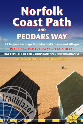
Norfolk Coast Path & Peddars Way
Trailblazer
Editorial: Trailblazer
ISBN: 978-1-912716-39-5
Encuadernación: Tapa blanda
Edición: 1
Número de páginas: 240
Tamaño: 12 x 19
Includes accommodation, pubs and restaurants in detailed guides to 45 towns and villages from Knettishall Heath to Hopton-on-Sea The Peddars Way runs 46 miles (74km) from Knettishall Heath on the Suffolk/Norfolk border, following an ancient dry route above the fens, mudflats and marshes to reach the coast at Holme-next-the-Sea. The Norfolk Coast Path (85½ miles/137km) begins in nearby Hunstanton and hugs the beautiful Norfolk coastline with its vast sandy beaches through Holkham, Blakeney, Cley and Cromer to end at Hopton-on-Sea. Together they form a superb 134-mile (215km) route*, one of the most straightforward, varied and enjoyable National Trails in Britain. (* including walk to Hunstanton from end of Peddars Way) Includes 77 detailed walking maps: the largest-scale maps available At just under 1:20,000 (8cm or 31/8 inches to 1 mile) these are bigger than even the most detailed walking maps currently available in the shops Unique mapping features walking times, directions, tricky junctions, places to stay, places to eat, points of interest. These are not general-purpose maps but fully edited maps drawn by walkers for walkers Itineraries for all walkers whether hiking the entire route or sampling highlights on day walks or short breaks o Detailed public transport information for all access points Practical information for all budgets What to see; where to eat (cafés, pubs and restaurants); where to stay (B&Bs, hotels, bunkhouses, hostels and campsites) Includes downloadable GPS waypoints
Sin stock